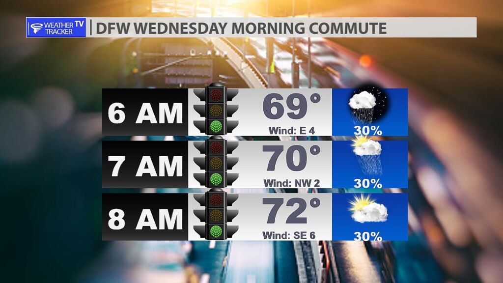
5:40 AM A few showers remain possible across the Metroplex this morning. Roadways may be damp to wet especially on the Tarrant county side of town. Expect temperatures in the 60s to near 70.

5:40 AM A few showers remain possible across the Metroplex this morning. Roadways may be damp to wet especially on the Tarrant county side of town. Expect temperatures in the 60s to near 70.

Here’s a look at Local Radar and Live Temperatures across North Texas.
DFW the rest of tonight: Mostly cloudy with a 50 percent chance of showers and T-Storms. Lows in the upper 60s. East winds around 5 mph.


From William Cole: Strong T-Storms will impact portions of eastern Hamilton, Coryell, eastern Lampasas and western Bell Counties through 215 AM
At 127 AM , Live Radar was tracking strong T-Storms along a line extending from 8 miles southwest of Cranfills Gap to 13 miles northwest of Copperas Cove to 7 miles southwest of Lampasas. Movement was southeast at 35 mph.
Wind Gusts Up To 50 Mph And Half Inch Hail. Gusty Winds Could Knock Down Tree Limbs And Blow Around Unsecured Objects. Minor Damage To Outdoor Objects Is Possible.
Stay with William Cole and Weather Tracker TV Dallas – Fort Worth for continuing coverage, online, on our app and on TV. Let’s stay safe together.
From William Cole: Strong T-Storms will impact portions of Montague and Wise Counties through 200 AM
At 122 AM , Live Radar was tracking strong T-Storms along a line extending from 6 miles north of Bellevue to 6 miles northwest of Poolville. Movement was east at 30 mph.
Wind Gusts Up To 50 Mph And Penny Size Hail. Gusty Winds Could Knock Down Tree Limbs And Blow Around Unsecured Objects. Minor Damage To Outdoor Objects Is Possible.
Stay with William Cole and Weather Tracker TV Dallas – Fort Worth for continuing coverage, online, on our app and on TV. Let’s stay safe together.
From William Cole: Strong T-Storms will impact portions of Jack and northeastern Palo Pinto Counties through 145 AM
At 1258 AM , Live Radar was tracking strong T-Storms along a line extending from 8 miles south of Windthorst to 7 miles northeast of Possum Kingdom Lake. Movement was east at 45 mph.
Wind Gusts Up To 50 Mph And Penny Size Hail. Gusty Winds Could Knock Down Tree Limbs And Blow Around Unsecured Objects. Minor Damage To Outdoor Objects Is Possible.
Stay with William Cole and Weather Tracker TV Dallas – Fort Worth for continuing coverage, online, on our app and on TV. Let’s stay safe together.
From William Cole: Strong T-Storms will impact portions of Hamilton, western Coryell, Lampasas, eastern Mills and southeastern Comanche Counties through 130 AM
At 1244 AM , Live Radar was tracking strong T-Storms along a line extending from 7 miles southeast of Dublin to 12 miles west of Evant to 8 miles southeast of Sloan. Movement was southeast at 40 mph.
Wind Gusts Up To 50 Mph And Half Inch Hail. Gusty Winds Could Knock Down Tree Limbs And Blow Around Unsecured Objects. Minor Damage To Outdoor Objects Is Possible.
Stay with William Cole and Weather Tracker TV Dallas – Fort Worth for continuing coverage, online, on our app and on TV. Let’s stay safe together.
From William Cole: A strong T-Storm will impact portions of Erath, eastern Eastland and Comanche Counties through 1230 AM
At 1147 PM , Live Radar was tracking a cluster of strong T-Storms from near Ranger to Gorman to Brownwood, moving east at 55 mph.
Wind Gusts Up To 50 Mph. Gusty Winds Could Knock Down Tree Limbs And Blow Around Unsecured Objects.
Stay with William Cole and Weather Tracker TV Dallas – Fort Worth for continuing coverage, online, on our app and on TV. Let’s stay safe together.
From William Cole: A strong T-Storm will impact portions of Eastland and Stephens Counties through 1145 PM
At 1039 PM , Live Radar was tracking a line of strong T-Storm from near Albany to Moran to Silver Valley, moving east at 35 mph.
Wind Gusts Up To 50 Mph. Gusty Winds Could Knock Down Tree Limbs And Blow Around Unsecured Objects.
Stay with William Cole and Weather Tracker TV Dallas – Fort Worth for continuing coverage, online, on our app and on TV. Let’s stay safe together.

William’s North Texas Hazardous Weather Forecast this Evening:
A complex of T-Storms is expected to move into our area from the west-northwest late tonight into early Wednesday morning. A few storms may become strong to severe, primarily west of Highway 281, and contain damaging wind gusts, frequent lightning, heavy rain, and small hail.

From William Cole: A T-Storm Watch has been issued in the Weather Tracker TV DFW coverage area for the following counties until 2:00 AM Wednesday. Erath, Hamilton, Jack, Palo Pinto, Stephens & Young.
We’ll have Live Severe Weather Coverage on the channel – which includes Texas’ #1 Storm Chasing Team – as needed. Be sure to download our free Weather Tracker TV DFW mobile app and add our Live channel to your Roku, Apple or Amazon Fire TV device.
Stay with William Cole and Weather Tracker TV Dallas – Fort Worth for continuing coverage, online, on our app and on TV. Let’s stay safe together.