William’s North Texas Hazardous Weather Forecast this Evening:
There is a chance of T-Storms across much of the region tonight. A few storms may be severe, primarily west of I-35/35W and north of I- 20. Damaging wind gusts is the primary threat.
William’s North Texas Hazardous Weather Forecast this Evening:
There is a chance of T-Storms across much of the region tonight. A few storms may be severe, primarily west of I-35/35W and north of I- 20. Damaging wind gusts is the primary threat.
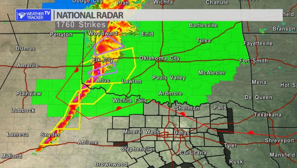
Tornado Watches are now in effect to the west and north of North Texas. A line of severe storms is pushing across Oklahoma and has now back built into parts of the Big Country. The southern extent of the line we will be monitoring as it approaches North Texas. The latest data continues to suggest the line will be weakening with time.

DFW tonight Partly cloudy in the evening, then showers and perhaps an isolated T-Storm after midnight. Breezy with lows in the lower 50s. South winds 15 to 25 mph, becoming west after midnight. Wind gusts up to 40 mph are possible. Chance of rain 90 percent. -William

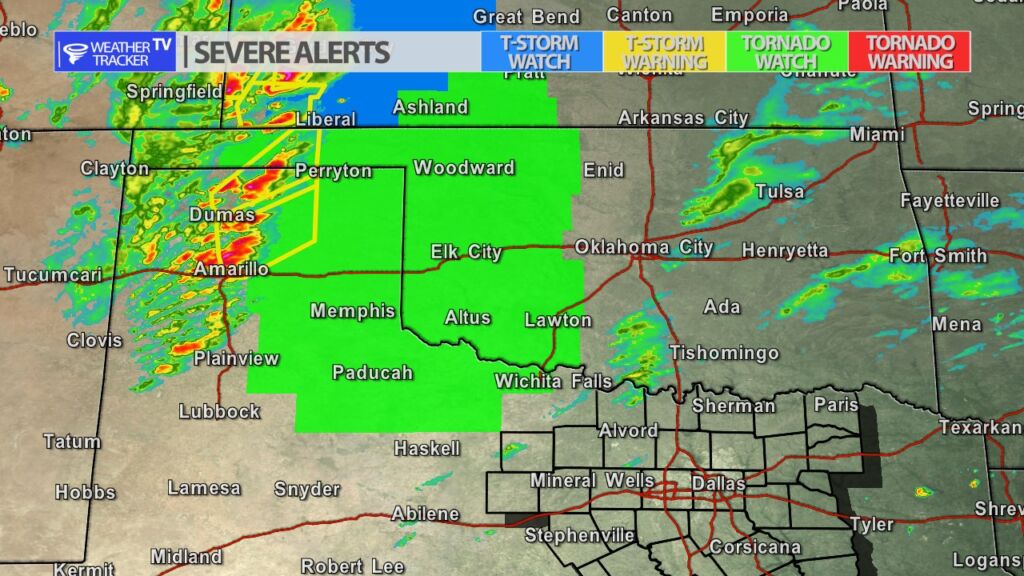
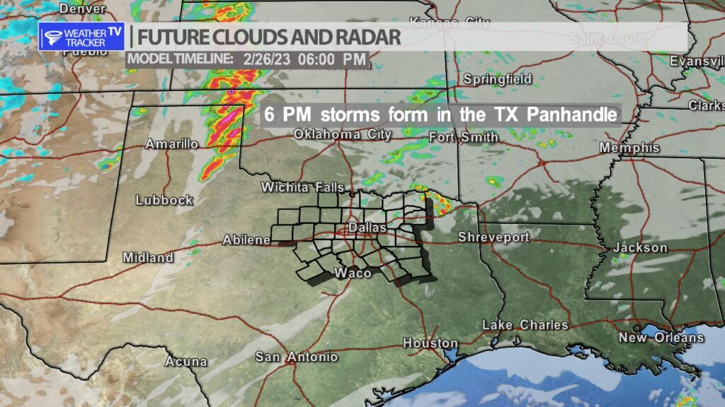
A Tornado Watch has been issued for parts of our Texas Panhandle and Oklahoma. Storms are rapidly developing near Amarillo. A weakening line of storms in still expected in North Texas late this evening and into the overnight.

Here’s a look at Live Temperatures across North Texas, Local Radar and the Updated Forecast Map.
DFW this afternoon Mostly cloudy. Areas of fog. Much warmer with highs in the mid 70s. South winds 10 to 15 mph. -William


From William Cole: A Dense Fog Advisory has been issued in the Weather Tracker TV DFW coverage area from now until 11:00 AM Sunday for Anderson, Bosque, Collin, Cooke, Dallas, Delta, Denton, Ellis, Erath, Fannin, Freestone, Grayson, Hamilton, Henderson, Hill, Hood, Hopkins, Hunt, Jack, Johnson, Kaufman, Lamar, Montague, Navarro, Palo Pinto, Parker, Rains, Rockwall, Somervell, Stephens, Tarrant, Van Zandt, Wise & Young Counties in North Texas.
For the Dense Fog Advisory, visibility as low as one quater mile. For the Wind Advisory, winds 20 to 30 mph with gusts up to 50 mph expected.
Stay with William Cole and Weather Tracker TV Dallas – Fort Worth for continuing coverage, online, on our app and on TV. Let’s stay safe together.
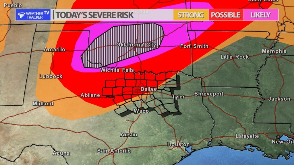
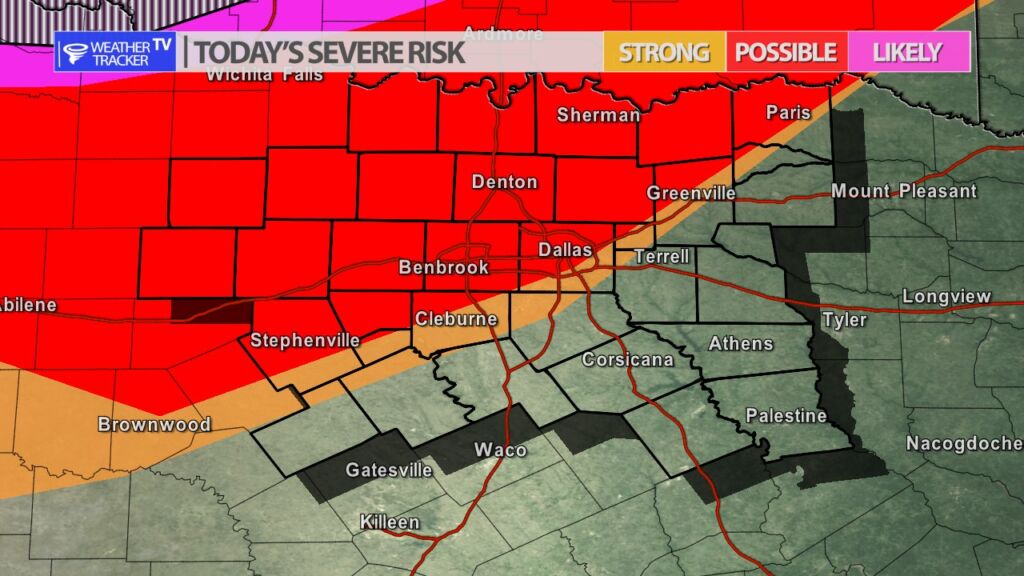
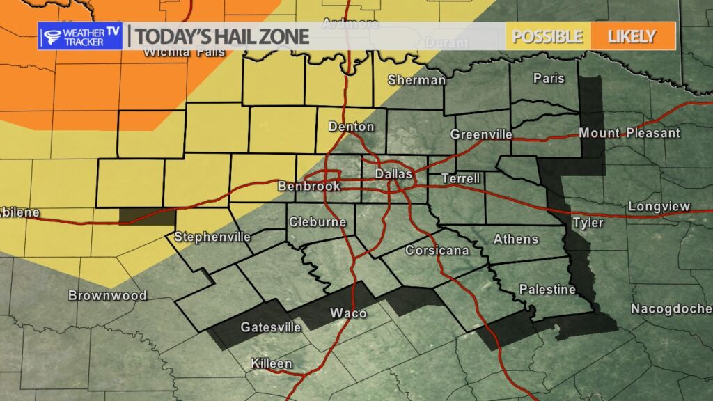
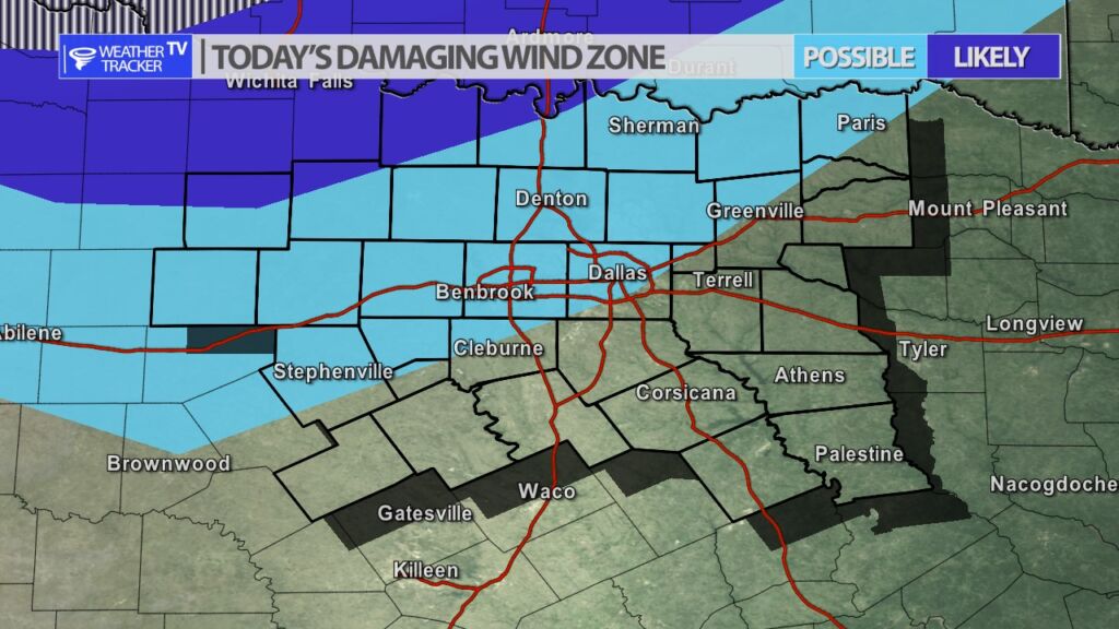
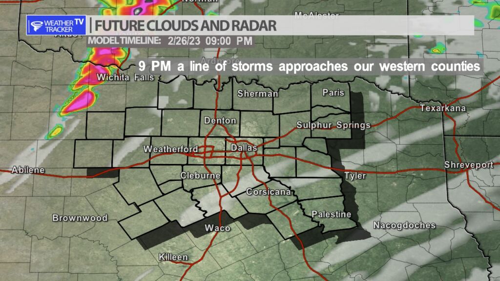
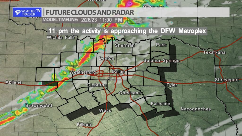
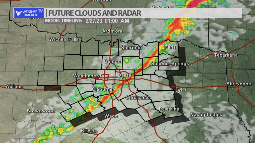
As a strong upper level storm system moves out into the southern plains this evening and tonight – a broken line of storms with embedded supercells will initially develop in our Texas Panhandle by 6 PM. The line will track into western Oklahoma with the greatest threat of severe weather tonight remaining in Oklahoma. The line will back build to the south through the evening and by 9 PM a southerly flank will be approaching our western counites. This southerly section initially could be quite severe – mainly in the Big Country – with rotating supercells possible out there. That activity will continue to form into a line with a weakening trend as it moves into North Texas. The line will approach Dallas – Fort Worth by 11 PM. The primary concern in North Texas will be strait line winds of 60 MPH+. Damaging hail will be possible in our western counties – especially with any rotating storm – and sizes could be up to golf balls. The hail threat will dramatically come down as the line moves deeper into North Texas with quarter sized hail being possible in the Metroplex. The tornado threat for North Texas is low however, anytime you’re dealing with a line of storms and a strong jet stream storm system you always have a concern of quick spin up tornadoes and that is something we will be monitoring tonight. Additional updates will be available here on the mobile app, on the channel and of course live severe weather coverage as needed.