NOW UPDATE | Monday 12:24 AM Collin, Dallas, Delta, Fannin, Hopkins, Hunt, Kaufman & Rockwall Counties

Texas Weather Tracker TV Alert

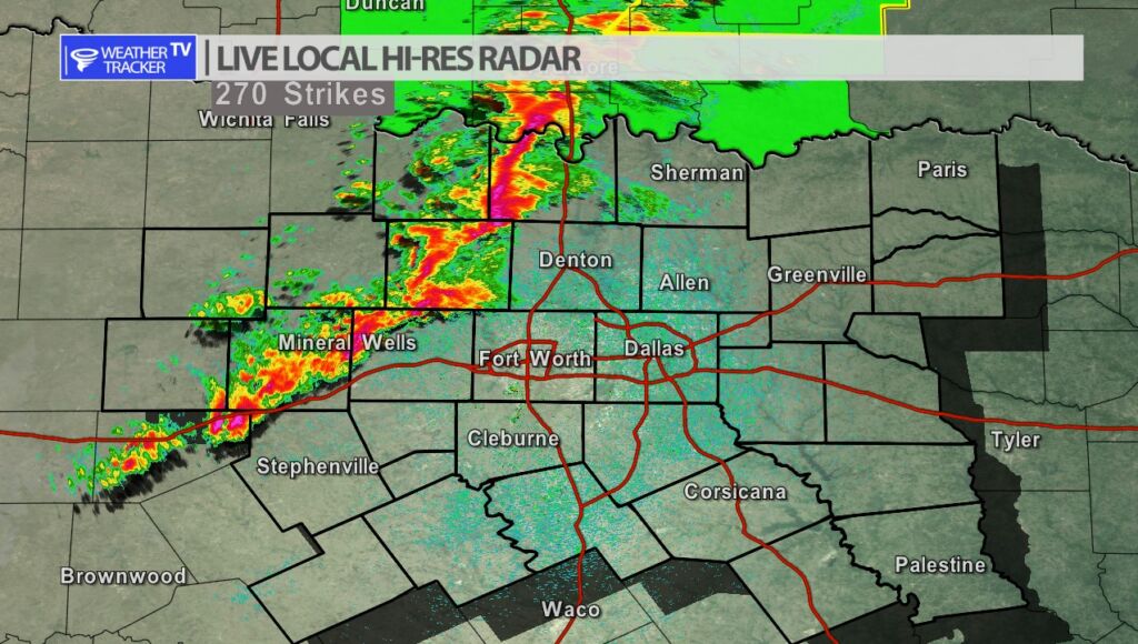
From William Cole: Strong T-Storms will impact portions of Rockwall, Hunt, northern Kaufman, western Hopkins, Delta, southeastern Collin, Dallas and southeastern Fannin Counties through 130 AM

At 1224 AM , Live Radar was tracking strong T-Storms along a line extending from near Wolfe City to near Midlothian. Movement was east at 50 mph.

Wind Gusts Of 50 To 55 Mph. Gusty Winds Could Knock Down Tree Limbs And Blow Around Unsecured Objects.

Stay with William Cole and Weather Tracker TV Dallas – Fort Worth for continuing coverage, online, on our app and on TV. Let’s stay safe together.

NOW UPDATE | Sunday 11:30 PM Collin, Dallas, Denton, Parker & Tarrant Counties

Texas Weather Tracker TV Alert

From William Cole: Strong T-Storms will impact portions of southeastern Denton, southeastern Parker, Tarrant, central Collin and Dallas Counties through 1230 AM

At 1129 PM , Live Radar was tracking strong T-Storms along a line extending from near Denton to 9 miles northwest of Godley. Movement was east at 35 mph.

Wind Gusts Of 50 To 55 Mph. Gusty Winds Could Knock Down Tree Limbs And Blow Around Unsecured Objects.

Stay with William Cole and Weather Tracker TV Dallas – Fort Worth for continuing coverage, online, on our app and on TV. Let’s stay safe together.

NOW UPDATE | Sunday 10:45 PM: Cooke & Grayson Counties

Texas Weather Tracker TV Alert

From William Cole: A strong T-Storm will impact portions of Cooke and western Grayson Counties through 1115 PM

At 1045 PM , Live Radar was tracking a strong T-Storm over Thackerville, or 10 miles south of Marietta, moving east at 55 mph.

Wind Gusts Of 50 To 55 Mph. Gusty Winds Could Knock Down Tree Limbs And Blow Around Unsecured Objects.

Stay with William Cole and Weather Tracker TV Dallas – Fort Worth for continuing coverage, online, on our app and on TV. Let’s stay safe together.

Severe Weather Update 10:16 PM: Palo Pinto County

Texas Weather Tracker TV Alert

From William Cole: A Severe T-Storm Warning continues for for Palo Pinto County in North TX until 10:30 PM.

At 1016 PM , a severe T-Storm was located near Mineral Wells, moving east at 50 mph.

Primary Threats: 60 Mph Wind Gusts And Penny Size Hail.

Stay with William Cole and Weather Tracker TV Dallas – Fort Worth for continuing coverage, online, on our app and on TV. Let’s stay safe together.

Severe Weather Update 10:03 PM: Palo Pinto County

Texas Weather Tracker TV Alert

From William Cole: A Severe T-Storm Warning continues for for Palo Pinto County in North TX until 10:30 PM.

At 1003 PM , a severe T-Storm was located near Graford, or 12 miles west of Mineral Wells, moving east at 50 mph.

Primary Threats: 60 Mph Wind Gusts And Quarter Size Hail.

Stay with William Cole and Weather Tracker TV Dallas – Fort Worth for continuing coverage, online, on our app and on TV. Let’s stay safe together.

9:47 PM | T-Storm Warning Palo Pinto County until 10:30 PM Sunday

Texas Weather Tracker TV Alert

From William Cole: A Severe T-Storm Warning has been issued in the Weather Tracker TV DFW coverage area for Palo Pinto County in North TX until 10:30 PM.

At 947 PM , a severe T-Storm was located over Possum Kingdom State Park, or 18 miles south of Graham, moving east at 50 mph.

Hometowns Impacted: Mineral Wells, Graford, Palo Pinto, Possum Kingdom Lake, Possum Kingdom State Park, Salesville, Oran And Peadenville.

Primary Threats: 60 Mph Wind Gusts And Quarter Size Hail.

Stay with William Cole and Weather Tracker TV Dallas – Fort Worth for continuing coverage, online, on our app and on TV. Let’s stay safe together.

Severe Weather Update 9:41 PM: Stephens County

Texas Weather Tracker TV Alert

From William Cole: A Severe T-Storm Warning continues for for Stephens County in North TX until 10:00 PM.

At 941 PM , a severe T-Storm was located 7 miles northwest of Caddo, or 10 miles east of Breckenridge, moving east at 55 mph.

Primary Threats: 60 Mph Wind Gusts And Quarter Size Hail.

Stay with William Cole and Weather Tracker TV Dallas – Fort Worth for continuing coverage, online, on our app and on TV. Let’s stay safe together.

Severe Weather Update 9:32 PM: Stephens County

Texas Weather Tracker TV Alert

From William Cole: A Severe T-Storm Warning continues for for Stephens County in North TX until 10:00 PM.

At 931 PM , a severe T-Storm was located near Breckenridge, moving east at 55 mph.

Primary Threats: 60 Mph Wind Gusts And Quarter Size Hail.

Stay with William Cole and Weather Tracker TV Dallas – Fort Worth for continuing coverage, online, on our app and on TV. Let’s stay safe together.

9:21 PM | T-Storm Warning Stephens County until 10:00 PM Sunday

Texas Weather Tracker TV Alert

From William Cole: A Severe T-Storm Warning has been issued in the Weather Tracker TV DFW coverage area for Stephens County in North TX until 10:00 PM.

At 920 PM , a severe T-Storm was located near Hubbard Creek Reservoir, or 10 miles west of Breckenridge, moving east at 55 mph.

Hometowns Impacted: Breckenridge, Hubbard Creek Reservoir, Crystal Falls, Caddo, Possum Kingdom Lake, Eolian, Ivan And Eliasville.

Primary Threats: 60 Mph Wind Gusts And Quarter Size Hail.

Stay with William Cole and Weather Tracker TV Dallas – Fort Worth for continuing coverage, online, on our app and on TV. Let’s stay safe together.