Current Set Up Across the Nation

From William Cole: A Flood Advisory has been issued for Dallas & Tarrant Counties in the Metroplex until 9:30 PM. Ponding on the roadways and localized street flooding is possible.
Remember if you see water across a roadway do not drive through it. Turn Around Don’t Drown.
Stay with William Cole and Weather Tracker TV Dallas – Fort Worth for continuing coverage, online, on our app and on TV. Let’s stay safe together.

If you have not already downloaded the Free Texas Weather Tracker TV mobile app – do that now. Search your app store for Texas Weather Tracker TV. Also, add our free Live Channel to your TV through Roku, Apple or Amazon Fire TV streaming players.

Like our forecasts? Love our severe weather coverage? Help support us and local Texas weather coverage. Join our Patreon for $2.99 per month. www.patreon.com/texasweathertrackertv


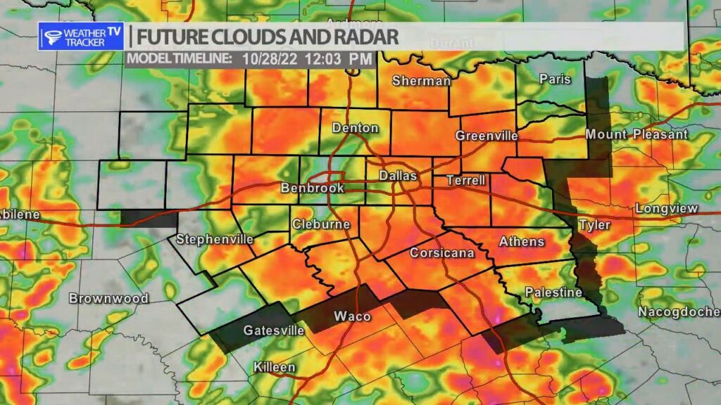
From William Cole: A strong T-Storm will impact portions of central Van Zandt and north central Henderson Counties through 515 PM
At 444 PM , Live Radar was tracking a strong T-Storm 9 miles north of Athens, moving north at 55 mph.
Winds In Excess Of 40 Mph And Half Inch Hail. Gusty Winds Could Knock Down Tree Limbs And Blow Around Unsecured Objects. Minor Damage To Outdoor Objects Is Possible.
Stay with William Cole and Weather Tracker TV Dallas – Fort Worth for continuing coverage, online, on our app and on TV. Let’s stay safe together.
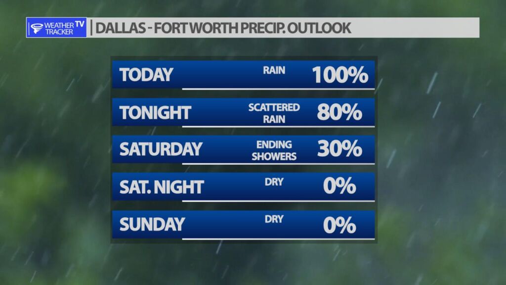
DFW tonight Showers with a chance of T-Storms in the evening, then showers likely with a slight chance of T-Storms after midnight. Lows in the mid 50s. North winds around 10 mph. Chance of rain near 100 percent. -William


Here’s a look at Live Temperatures across North Texas, Local Radar and the Updated Forecast Map.
DFW this afternoon Showers with a chance of T-Storms. Cooler with highs around 60. Northeast winds 10 to 15 mph. Chance of rain near 100 percent. -William


From the National Hurricane Center:
For the North Atlantic Caribbean Sea and the Gulf of Mexico:Eastern Caribbean:A broad area of low pressure over the southeastern Caribbean Seais producing a large area of disorganized showers and T-Stormsextending from the Windward Islands west-northwestward for severalhundred miles. Environmental conditions are forecast to beconducive for gradual development over the next few days, and atropical depression is likely to form this weekend or earlynext week while the disturbance moves slowly westward orwest-northwestward over the central Caribbean Sea. Regardless ofdevelopment, locally heavy rainfall is possible over portions ofthe Lesser Antilles, the Virgin Islands, and Puerto Rico throughthis weekend.* Formation chance through 48 hours low 20 percent.* Formation chance through 5 days high 70 percent.Southwestern Atlantic:A large area of cloudiness and showers extending from near Bermudasouthward over the western Atlantic for several hundred miles isassociated with a trough of low pressure. A broad area of lowpressure is expected to form along the northern portion of thetrough axis later today, but environmental conditions are forecastto be only marginally conducive, and any development should be slowto occur. By late Saturday, upper-level winds are forecast tobecome even less favorable for development, and the low is expectedto begin interacting with an approaching frontal system.* Formation chance through 48 hours low 20 percent.* Formation chance through 5 days low 20 percent.Forecaster Brown


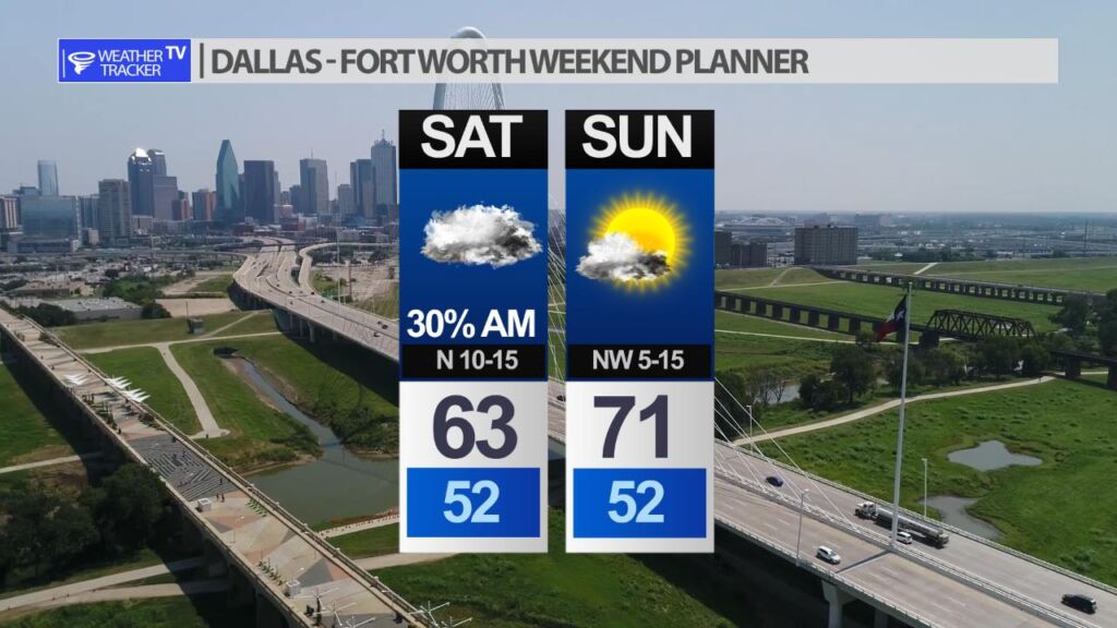
Saturday starts chilly and cloudy with a few lingering showers. Shower chances taper off with clearing skies through the day. Sunday is the pick day of the weekend – mostly sunny with a high near 70.
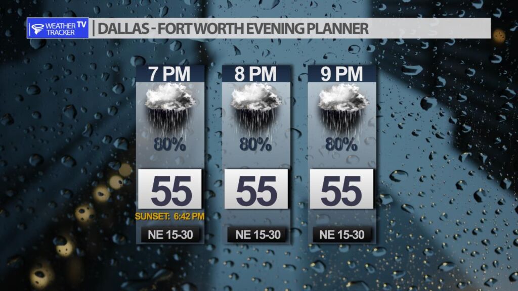
It you’re making Friday evening plans – off and on scattered showers will continue with temperatures in the 50’s.
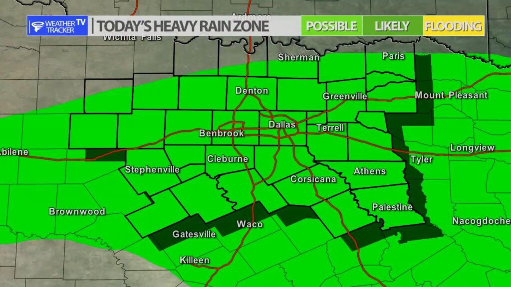
It’s going to be a wet Friday with rain likely through the day. The rain becomes scattered by late afternoon into the evening. If you’re making Friday evening plans or even Friday late night plans – prepare for a wet and chilly forecast. Rainfall remains moderate today so other than ponding on the roadways – the flooding potential is minimal – this is a good ol’ fashion Fall soaker. While there is no risk of severe weather in North Texas today the risk increases in Central Texas down into the Coastal Plains.