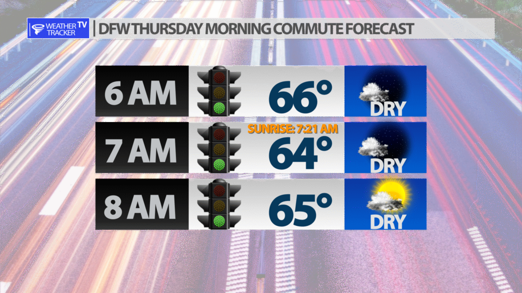
It’s another dry, but cool and crisp morning commute in the Metroplex with temperatures in the 60’s.
It’s another dry, but cool and crisp morning commute in the Metroplex with temperatures in the 60’s.

IAN NOW A TROPICAL STORM… …BUT STILL EXPECTED TO PRODUCE STRONG WINDS, HEAVY RAINS, AND STORM SURGE ACROSS PORTIONS OF FLORIDA, GEORGIA, AND THE CAROLINAS
At 500 AM EDT (0900 UTC), the center of Tropical Storm Ian was located near latitude 28.0 North, longitude 80.9 West. Ian is moving toward the northeast near 8 mph (13 km/h). A turn toward the north-northeast is expected later today, followed by a turn toward the north and north-northwest with an increase in forward speed Friday and Friday night. On the forecast track, the center of Ian is expected to move off the east-central coast of Florida later today and then approach the coast of South Carolina on Friday. The center will move farther inland across the Carolinas Friday night and Saturday.


Here’s a look at Local Radar and Live Temperatures across North Texas.
DFW the rest of tonight: Clear. Lows in the lower 60s. Southeast winds around 5 mph.

IAN EXPECTED TO EMERGE OVER THE ATLANTIC WATERS LATER TODAY… …FLOODING RAINS CONTINUE ACROSS CENTRAL AND NORTHERN FLORIDA
At 200 AM EDT (0600 UTC), the center of Hurricane Ian was located inland near latitude 27.7 North, longitude 81.1 West. Ian is moving toward the northeast near 9 mph (15 km/h), and a turn toward the north-northeast and north is expected during the next couple of days. On the forecast track, the center of Ian is expected to move across central Florida this morning and emerge over the western Atlantic later today. Ian is forecast to turn northward on Friday and approach the northeastern Florida, Georgia, and South Carolina coasts.
IAN CONTINUING TO BATTER THE FLORIDA PENINSULA WITH WINDS, STORM SURGE, AND FLOODING… …EXPECTED TO MOVE INTO THE ATLANTIC TOMORROW
At 1100 PM EDT (0300 UTC), the center of Hurricane Ian was located near latitude 27.5 North, longitude 81.4 West. Ian is moving toward the north-northeast near 8 mph (13 km/h), and a turn toward the northeast and north is expected during the next couple of days. On the forecast track, the center of Ian is expected to move across central Florida overnight and Thursday morning and emerge over the western Atlantic by late Thursday. Ian is forecast to turn northward on Friday and approach the northeastern Florida, Georgia and South Carolina coasts.

William’s North Texas Hazardous Weather Forecast this Evening:
No hazardous weather is expected at this time.

IAN CONTINUING TO BATTER THE FLORIDA PENINSULA WITH CATASTROPHIC STORM SURGE, WINDS, AND FLOODING
At 800 PM EDT (0000 UTC), the eye of Hurricane Ian was located near latitude 27.2 North, longitude 81.7 West. Ian is moving toward the north-northeast near 8 mph (13 km/h). On the forecast track, the center of Ian is expected to move across central Florida tonight and Thursday morning and emerge over the western Atlantic by late Thursday. Ian is forecast to turn northward on Friday and approach the northeastern Florida, Georgia and South Carolina coasts.
DFW tonight Clear. Lows in the lower 60s. Southeast winds around 5 mph. -William

IAN BATTERING THE FLORIDA PENINSULA WITH CATASTROPHIC STORM SURGE, WINDS, AND FLOODING… …NEW WATCHES AND WARNINGS ISSUED FOR NORTH AND SOUTH CAROLINA
At 500 PM EDT (2100 UTC), the eye of Hurricane Ian was located near latitude 26.9 North, longitude 82.0 West. Ian is moving toward the north-northeast near 8 mph (13 km/h). On the forecast track, the center of Ian is expected to move across central Florida tonight and Thursday morning and emerge over the western Atlantic by late Thursday. Ian is forecast to turn northward on Friday and approach the northeastern Florida coast, Georgia and South Carolina coasts late Friday.