ALERT 3:18 PM | An Air Quality Alert has been issued for the DFW Metroplex for Tuesday September 27

Texas Weather Tracker TV Alert

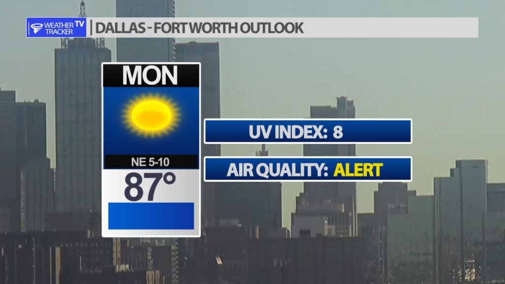
From William Cole: A Air Quality Alert has been issued for the following counties in North Texas until Tuesday September 27. Collin, Dallas, Denton, Ellis, Henderson, Hunt, Johnson, Kaufman, Parker, Rockwall, Tarrant & Wise.

OZONE ACTION DAY The Texas Commission on Environmental Quality (TCEQ) has issued an Ozone Action Day for the Dallas-Fort Worth area for Tuesday, September 27, 2022. Atmospheric conditions are expected to be favorable for producing high levels of ozone air pollution in the Dallas-Fort Worth area on Wednesday. You can help prevent ozone pollution by sharing a ride, walking, riding a bicycle, taking your lunch to work, avoiding drive-through lanes, conserving energy, and keeping your vehicle properly tuned. For more information on ozone: Ozone: The Facts (www.tceq.texas.gov/goto/ozonefacts) Air North Texas: (www.airnorthtexas.org) EPA Air Now (www.airnow.gov/index.cfm?action.local_state&STATEID=45&TAB=0) Take care of Texas (www.takecareoftexas.org) North Central Texas Council of Governments Air Quality (www.nctcog.org/trans/air/index.asp)

Stay with William Cole and Weather Tracker TV Dallas – Fort Worth for continuing coverage online, on our free mobile app and on TV thru Roku, Apple and Amazon Fire TV.

National Hurricane Center Update on Ian

Texas Weather Tracker TV Alert

IAN CONTINUES TO INTENSIFY… …CONDITIONS IN WESTERN CUBA TO DETERIORATE THIS EVENING AND TONIGHT WITH SIGNIFICANT WIND AND STORM SURGE IMPACTS EXPECTED

At 200 PM EDT (1800 UTC), the center of Hurricane Ian was located near latitude 19.7 North, longitude 83.0 West. Ian is moving toward the north-northwest near 13 mph (20 km/h). A turn toward the north with a slightly slower forward speed is expected on Tuesday. A turn toward the north-northeast with a further reduction in forward speed is forecast on Wednesday. On the forecast track, the center of Ian is expected to move near or over western Cuba tonight and early Tuesday. Ian will then emerge over the southeastern Gulf of Mexico on Tuesday, pass west of the Florida Keys late Tuesday, and approach the west coast of Florida on Wednesday into Thursday.

Download App

Atlantic Tropical Weather Outlook

Texas Weather Tracker TV Alert

From the National Hurricane Center:

For the North Atlantic Caribbean Sea and the Gulf of Mexico:Active Systems:The National Hurricane Center is issuing advisories on recentlyupgraded Hurricane Ian, located over the northwestern Caribbean Sea.Central Tropical Atlantic:Shower and T-Storm activity associated with an area of lowpressure located several hundred miles west of the Cabo VerdeIslands is showing signs of organization this morning.Environmental conditions appear conducive for additionaldevelopment, and a tropical depression is likely to form during thenext couple of days before upper-level winds become less favorabletoward the end of the week. The system is expected to meanderduring the next day or two and then move slowly north-northwestward.* Formation chance through 48 hours high 70 percent.* Formation chance through 5 days high 70 percent.Forecaster Papin

National Hurricane Center Update on Ian

Texas Weather Tracker TV Alert

IAN FORECAST TO CONTINUE RAPIDLY STRENGTHENING… …CONDITIONS IN WESTERN CUBA TO DETERIORATE THIS EVENING AND TONIGHT WITH SIGNIFICANT WIND AND STORM SURGE IMPACTS EXPECTED

At 1100 AM EDT (1500 UTC), the center of Hurricane Ian was located near latitude 19.1 North, longitude 82.7 West. Ian is moving toward the northwest near 13 mph (20 km/h). A north-northwestward motion is expected to begin later today, followed by a northward motion on Tuesday with a slightly slower forward speed. A turn toward the north-northeast with a further reduction in forward speed is forecast on Wednesday. On the forecast track, the center of Ian is expected to pass near or west of the Cayman Islands today, and near or over western Cuba tonight and early Tuesday. Ian will then emerge over the southeastern Gulf of Mexico on Tuesday, pass west of the Florida Keys late Tuesday, and approach the west coast of Florida on Wednesday into Thursday.

Download App