DFW tonight Mostly clear in the evening, then becoming partly cloudy. Lows in the lower 70s. Southeast winds 5 to 10 mph. -William

DFW tonight Mostly clear in the evening, then becoming partly cloudy. Lows in the lower 70s. Southeast winds 5 to 10 mph. -William

Here’s a look at Live Temperatures across North Texas, Local Radar and the Updated Forecast Map.
DFW this afternoon Sunny. Highs in the lower 90s. East winds 5 to 10 mph. -William


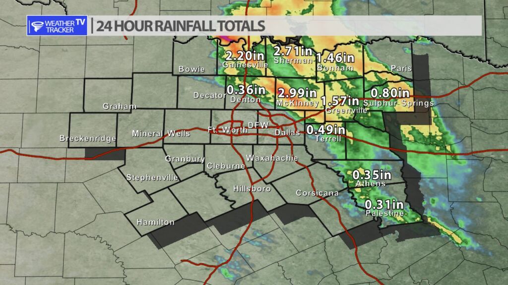
A storm complex arrived in North Texas late yesterday evening from Oklahoma. It produced severe weather (hail and wind), but also put down some big rainfall totals – 1″ to nearly 3″ rainfall totals were common. However, the rain was confined to our northern and eastern counites – most of North Texas including Dallas and Fort Worth missed out.


William’s North Texas Hazardous Weather Forecast for Monday:
No hazardous weather is expected at this time.


DFW today Sunny. Highs in the lower 90s. East winds 5 to 10 mph. -William

From William Cole: A strong T-Storm will impact portions of southern Grayson County through 430 AM
At 328 AM , Live Radar was tracking a strong T-Storm near Pottsboro, or 9 miles east of Whitesboro, moving southeast at 30 mph.
Half Inch Hail. Minor Damage To Outdoor Objects Is Possible.
Stay with William Cole and Weather Tracker TV Dallas – Fort Worth for continuing coverage, online, on our app and on TV. Let’s stay safe together.

From William Cole: A Severe T-Storm Warning continues for for Collin & Denton Counties in North TX until 3:15 AM.
At 300 AM , a severe T-Storm was located near Pilot Point, or 16 miles east of Sanger, moving southeast at 25 mph.
Primary Threats: Quarter Size Hail.
Stay with William Cole and Weather Tracker TV Dallas – Fort Worth for continuing coverage, online, on our app and on TV. Let’s stay safe together.