

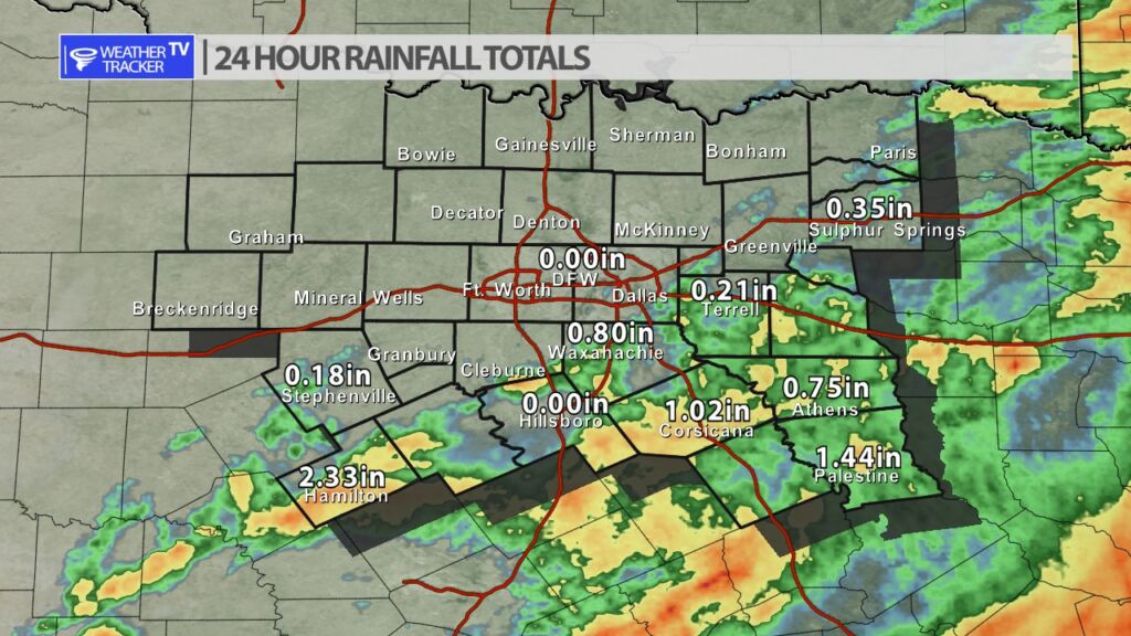
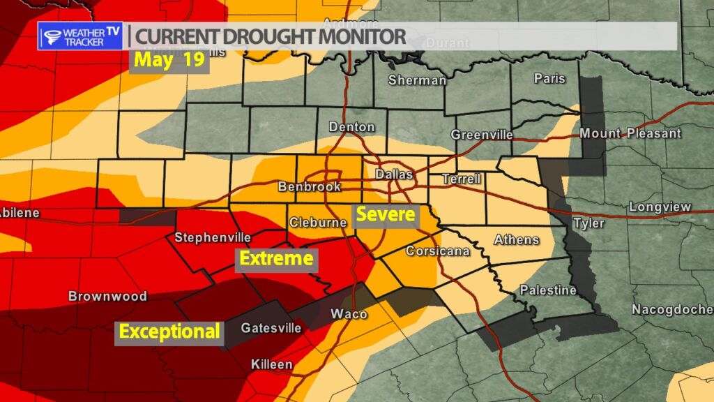
While most of North Texas missed out on rainfall yesterday – our southern counties did not. A strong cold front moving through the area was the trigger for late day rain and storms. The activity was mostly confined to I-20 corridor and locations to the south. This was a very generous rain with locations picking up between 1″ to 2″+. This is also great news for Hamilton and Bosque counties who are currently under exceptional drought criteria.


William’s North Texas Hazardous Weather Forecast for Sunday:
Isolated to scattered T-Storms are possible across Central Texas this afternoon, then across North Texas tonight. Severe weather is not anticipaed, but small hail will be possible in the strongest storms.


DFW today Mostly cloudy. Much cooler with highs around 70. North winds 10 to 15 mph. -William

Here’s a look at Local Radar and Live Temperatures across North Texas.
DFW the rest of tonight: Cloudy. Scattered showers and perhaps an isolated T-Storm. Some T-Storms may be severe with heavy rainfall. Much cooler with lows in the upper 50s. North winds 15 to 20 mph, diminishing to 10 to 15 mph. Chance of rain 30 percent.


From William Cole: A Severe T-Storm Warning continues for for Anderson & Henderson Counties in North TX until 10:15 PM.
At 940 PM , severe T-Storms were located along a line extending from near Athens to Neches to Elkhart, moving east at 40 mph. Tree damage and near 60 mph winds were reported in Palestine with these storms.
Primary Threats: 65 Mph Wind Gusts And Nickel Size Hail.
Stay with William Cole and Weather Tracker TV Dallas – Fort Worth for continuing coverage, online, on our app and on TV. Let’s stay safe together.
From William Cole: A Severe T-Storm Warning continues for for Anderson, Freestone, Henderson & Navarro Counties in North TX until 10:15 PM.
At 916 PM , severe T-Storms were located along a line extending from Cross Ranch to Tennessee Colony to Tucker to Oakwood, moving east at 50 mph. At 915PM, 60 mph winds were observed in Tucker.
Primary Threats: 65 Mph Wind Gusts And Nickel Size Hail.
Stay with William Cole and Weather Tracker TV Dallas – Fort Worth for continuing coverage, online, on our app and on TV. Let’s stay safe together.
From William Cole: A Severe T-Storm Warning continues for for Freestone & Navarro Counties in North TX until 9:15 PM.
At 904 PM , severe T-Storms were located along a line extending from near Eureka to Fairfield to Buffalo, moving east at 35 mph.
Primary Threats: 60 Mph Wind Gusts And Quarter Size Hail.
Stay with William Cole and Weather Tracker TV Dallas – Fort Worth for continuing coverage, online, on our app and on TV. Let’s stay safe together.