
Current Set Up Across the Nation

From William Cole: A strong T-Storm will impact portions of southeastern Hamilton, northwestern Coryell and north central Lampasas Counties through 730 PM
At 653 PM , Live Radar was tracking a strong T-Storm near Evant, or 19 miles south of Hamilton, moving northeast at 40 mph.
Winds In Excess Of 30 Mph And Nickel Size Hail. Gusty Winds Could Knock Down Tree Limbs And Blow Around Unsecured Objects. Minor Damage To Outdoor Objects Is Possible.
Stay with William Cole and Weather Tracker TV Dallas – Fort Worth for continuing coverage, online, on our app and on TV. Let’s stay safe together.
From William Cole: A strong T-Storm will impact portions of central Hamilton, northwestern Coryell and southwestern Bosque Counties through 645 PM
At 619 PM , Live Radar was tracking a strong T-Storm 8 miles southeast of Hamilton, moving northeast at 40 mph.
Winds In Excess Of 30 Mph And Nickel Size Hail. Gusty Winds Could Knock Down Tree Limbs And Blow Around Unsecured Objects. Minor Damage To Outdoor Objects Is Possible.
Stay with William Cole and Weather Tracker TV Dallas – Fort Worth for continuing coverage, online, on our app and on TV. Let’s stay safe together.
From William Cole: A strong T-Storm will impact portions of Hamilton County through 600 PM
At 532 PM , Live Radar was tracking a strong T-Storm near Evant, or 11 miles southwest of Hamilton, moving northeast at 25 mph.
Winds In Excess Of 40 Mph And Nickel Size Hail. Gusty Winds Could Knock Down Tree Limbs And Blow Around Unsecured Objects. Minor Damage To Outdoor Objects Is Possible.
Stay with William Cole and Weather Tracker TV Dallas – Fort Worth for continuing coverage, online, on our app and on TV. Let’s stay safe together.
From William Cole: A strong T-Storm will impact portions of southwestern Hamilton County through 545 PM
At 513 PM , Live Radar was tracking a strong T-Storm 7 miles west of Evant, or 16 miles southwest of Hamilton, moving northeast at 10 mph.
Winds In Excess Of 40 Mph And Penny Size Hail. Gusty Winds Could Knock Down Tree Limbs And Blow Around Unsecured Objects. Minor Damage To Outdoor Objects Is Possible.
Stay with William Cole and Weather Tracker TV Dallas – Fort Worth for continuing coverage, online, on our app and on TV. Let’s stay safe together.
DFW tonight Mostly cloudy. Showers and T-Storms likely after midnight. Lows in the upper 60s. Southeast winds 5 to 10 mph. Chance of rain 70 percent. -William


From William Cole: A Areal Flood Watch has been issued for the following counties in North Texas until 7:00 PM Wednesday. Anderson, Freestone, Henderson, Kaufman, Navarro, Rains & Van Zandt.
WHAT Flooding caused by excessive rainfall is possible. WHERE Portions of north central Texas, northeast Texas and south central Texas, including the following counties, in north central Texas, Freestone, Kaufman, Limestone and Navarro. In northeast Texas, Anderson, Henderson, Leon, Rains and Van Zandt. In south central Texas, Robertson. WHEN From Tuesday morning through Wednesday evening. IMPACTS Flooding may occur in urban and poor-drainage areas. Heavy rainfall could also cause flooding of creeks, streams, and rivers. ADDITIONAL DETAILS – Rainfall totals of 2 to 4 inches, with isolated higher amounts possible.
Stay with William Cole and Texas Weather Tracker TV for continuing coverage, online, on our app and on TV.

If you have not already downloaded the Free Texas Weather Tracker TV mobile app – do that now. Search your app store for Texas Weather Tracker TV. Also, add our free Live Channel to your TV through Roku, Apple or Amazon Fire TV streaming players.

Like our forecasts? Love our severe weather coverage? Help support us and local Texas weather coverage. Join our Patreon for $2.99 per month. www.patreon.com/texasweathertrackertv


Here’s a look at Live Temperatures across North Texas, Local Radar and the Updated Forecast Map.
DFW this afternoon Mostly cloudy. Highs in the upper 70s. Southeast winds 5 to 10 mph. -William


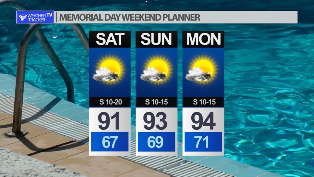
The North Texas Memorial Day Weekend forecast can be summed up very easily – mostly sunny and hotter. The humidity will also be high so heat index values will be creeping up near 100.

