

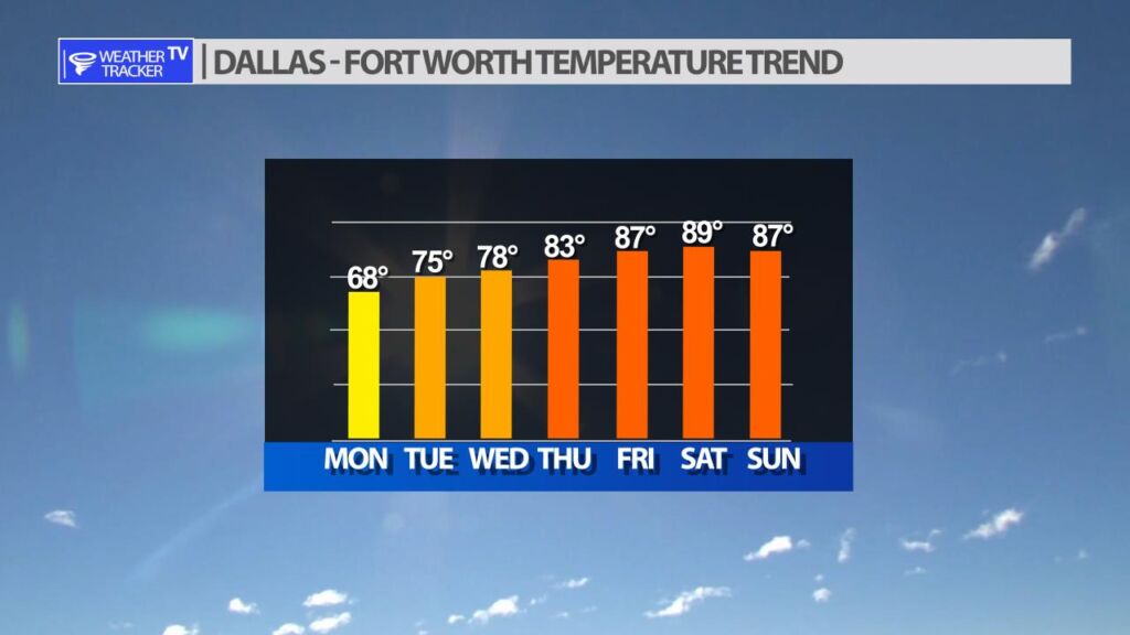
The temperature trend this week will be up across North Texas. Today will be the coolest day with highs in the 60’s. Tuesday and Wednesday look beautiful with highs in the 70’s and dry (less humid) air. The Gulf of Mexico moisture returns with warmer temperatures to close out your work week.
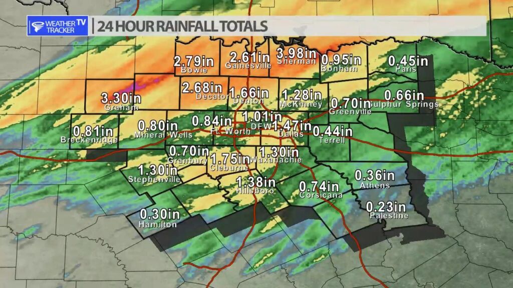
We received a generous drink of rain across North Texas yesterday and this morning. The good news is we got most of it without severe weather. At DFW officially we have been running a five inch rainfall deficit for the year – so we have been desperate for rain across North Texas. This will not completely catch us up, but it will put a big dent in the drought criteria.


William’s North Texas Hazardous Weather Forecast for Monday:
T-Storms are expected today, mainly across Central Texas. A few strong storms with gusty winds and small hail are possible. Some isolated areas of heavy rainfall and localized flooding are also possible.


DFW today Mostly cloudy. A chance of showers and T-Storms this morning, then a slight chance of showers and T-Storms this afternoon. Cooler with highs around 70. Northeast winds 10 to 15 mph, becoming north 15 to 20 mph this afternoon. Chance of rain 50 percent. -William

Here’s a look at Local Radar and Live Temperatures across North Texas.
DFW the rest of tonight: Showers with T-Storms likely. Lows in the upper 50s. North winds 5 to 10 mph. Chance of rain near 100 percent.


From William Cole: A Areal Flood Advisory has been issued for Denton County in the Metroplex until 3:30 AM. Ponding on the roadways and localized street flooding is possible.
Remember if you see water across a roadway do not drive through it. Turn Around Don’t Drown.
Stay with William Cole and Weather Tracker TV Dallas – Fort Worth for continuing coverage, online, on our app and on TV. Let’s stay safe together.

If you have not already downloaded the Free Texas Weather Tracker TV mobile app – do that now. Search your app store for Texas Weather Tracker TV. Also, add our free Live Channel to your TV through Roku, Apple or Amazon Fire TV streaming players.

Like our forecasts? Love our severe weather coverage? Help support us and local Texas weather coverage. Join our Patreon for $2.99 per month. www.patreon.com/texasweathertrackertv


From William Cole: A Flash Flood Warning has been issued in the Weather Tracker TV DFW coverage area for Grayson County in North TX until 2:00 AM.
At 1203 AM , Live Radar and automated rain gauges indicated T-Storms producing heavy rain across the warned area. Between 3 and 5 inches of rain have fallen. Additional rainfall amounts up to 1 inch are possible. Flash flooding is already occurring. Emergency management has reported numerous road closures, as well as stalled vehicles due to flooding, particularly along the Highway 75 corridor through Sherman.
Remember if you see water across a roadway do not drive through it. Turn Around Don’t Drown.
Stay with William Cole and Weather Tracker TV Dallas – Fort Worth for continuing coverage, online, on our app and on TV. Let’s stay safe together.