
William’s North Texas Hazardous Weather Forecast this Evening:
There is a chance of T-Storms mainly north of I-20 this evening and east of I-35 after midnight. A few storms may become severe with large hail and damaging wind being the main threats.
William’s North Texas Hazardous Weather Forecast this Evening:
There is a chance of T-Storms mainly north of I-20 this evening and east of I-35 after midnight. A few storms may become severe with large hail and damaging wind being the main threats.

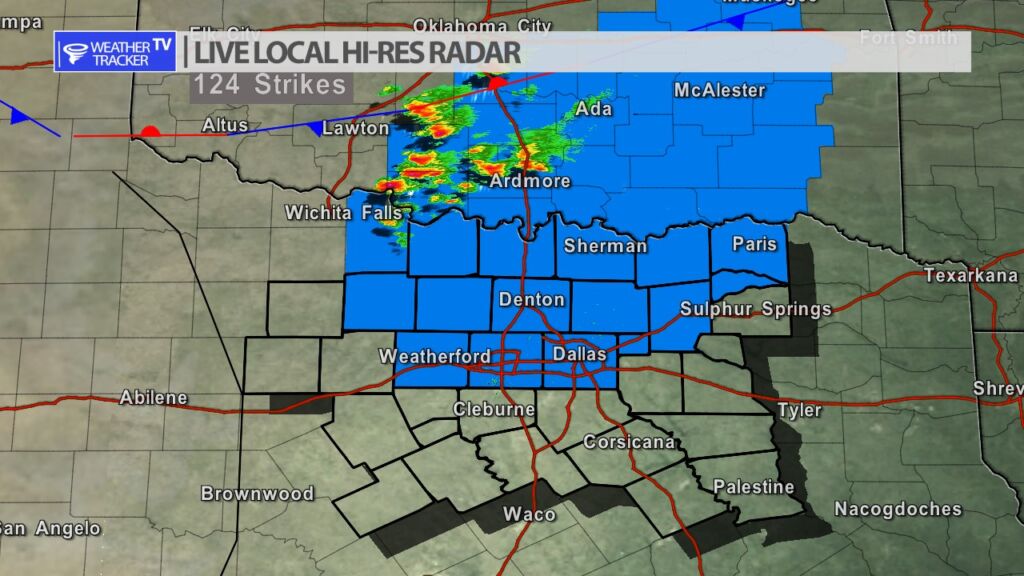
Things remain quiet in North Texas with a cluster of storms crossing the Red River into Oklahoma. Currently the “cap” or thunderstorm limiting factor in the atmosphere remains strong. Later this evening as the cold front begins to push into the area – it may add just enough lift that scattered storms may be possible. We’re tracking it. T-Storm Watch continues until 10 PM.
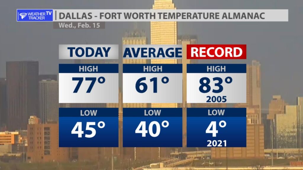
It was warm, breezy and humid this afternoon in the Metroplex with a daytime high of 77. The record low was just two years ago — 4 degrees above zero. Luckily we’re not dealing with anything like that today.
DFW tonight Partly cloudy with a chance of showers and T-Storms in the evening, then mostly clear with a slight chance of T-Storms after midnight. Some T-Storms may be severe. Less humid with lows in the upper 30s. Southwest winds 10 to 15 mph, becoming northwest 10 to 20 mph with gusts up to 30 mph after midnight. Chance of rain 50 percent. -William

From William Cole: A T-Storm Watch has been issued in the Weather Tracker TV DFW coverage area for the following counties until 10:00 PM Wednesday. Collin, Cooke, Dallas, Delta, Denton, Fannin, Grayson, Hunt, Jack, Lamar, Montague, Parker, Rockwall, Tarrant & Wise.
We’ll have Live Severe Weather Coverage on the channel – which includes Texas’ #1 Storm Chasing Team – as needed. Be sure to download our free Weather Tracker TV DFW mobile app and add our Live channel to your Roku, Apple or Amazon Fire TV device.
Stay with William Cole and Weather Tracker TV Dallas – Fort Worth for continuing coverage, online, on our app and on TV. Let’s stay safe together.
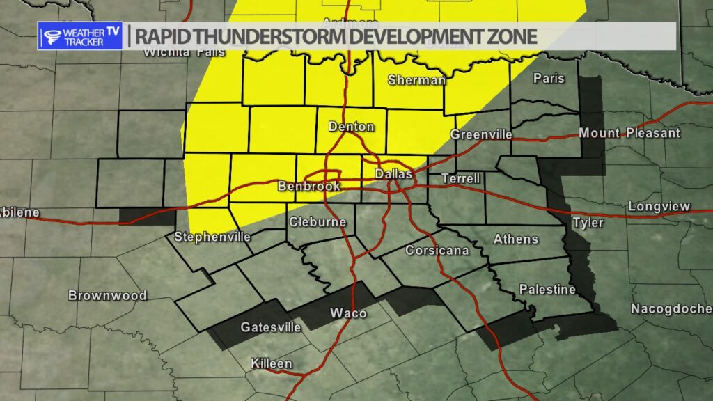
The Storm Prediction Center is monitoring parts of North Texas for a possible weather watch.
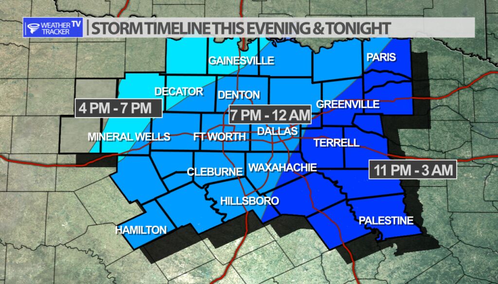
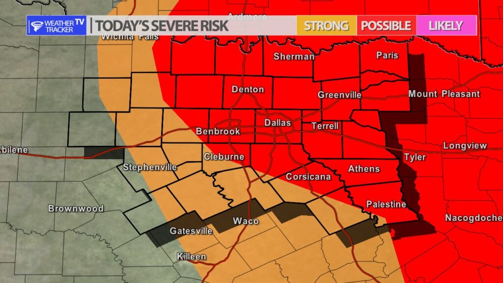
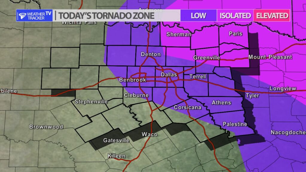
A strong upper level storm system is approaching from the west, and that combined with increasing Gulf of Mexico moisture this afternoon are a few of the weather pieces of the puzzle that are now quickly coming together to offer parts of North Texas a chance of severe weather this evening. Storms will initial form after 4 pm northwest of Dallas – Fort Worth and then track east through the evening. The severe weather probabilities are not incredibly high but severe weather should be expected. The main concern is wind gusts over 60 mph, hail up to the size of golf balls and there is a chance of a tornado warning or two. If you’re making Wednesday evening plans stay alert to changing weather conditions – especially if you will be on area roads – because of the hail and severe weather concerns. As always, we will have more updates here and live severe weather coverage on the channel as needed.

Here’s a look at Live Temperatures across North Texas, Local Radar and the Updated Forecast Map.
DFW REST OF today Mostly sunny. Highs in the upper 70s. South winds 10 to 15 mph, increasing to 15 to 20 mph with gusts up to 30 mph this afternoon. -William

