
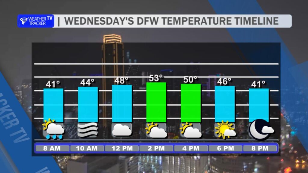
DFW today Cloudy. Patchy fog this morning. A chance of showers and T-Storms this morning. Highs in the mid 50s. North winds around 5 mph, becoming northwest 10 to 15 mph this afternoon. Chance of rain 20 percent. -William

DFW today Cloudy. Patchy fog this morning. A chance of showers and T-Storms this morning. Highs in the mid 50s. North winds around 5 mph, becoming northwest 10 to 15 mph this afternoon. Chance of rain 20 percent. -William
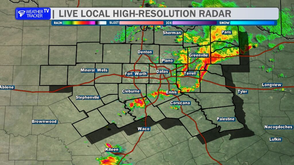
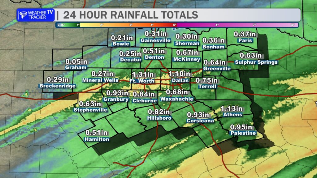
6AM- We saw another round of heavy rain overnight. Most of the activity is tapering off in the Metroplex. 24 hour rainfall totals were generous. We climb to around 50 this afternoon before a cold front arrives late day.


From William Cole: A strong T-Storm will impact portions of Rockwall, southwestern Hunt, northern Kaufman, southeastern Collin and eastern Dallas Counties through 545 AM
At 513 AM , Live Radar was tracking a strong T-Storm near Mesquite, moving east at 45 mph.
Winds In Excess Of 30 Mph. Gusty Winds Could Knock Down Tree Limbs And Blow Around Unsecured Objects.
Stay with William Cole and Weather Tracker TV Dallas – Fort Worth for continuing coverage, online, on our app and on TV. Let’s stay safe together.

From William Cole: Strong T-Storms will impact portions of northern Johnson, Tarrant, northwestern Ellis and Dallas Counties through 500 AM
At 424 AM , Live Radar was tracking strong T-Storms along a line extending from near Haslet to Westworth Village to near Godley. Movement was east at 50 mph.
Winds In Excess Of 30 Mph And Pea Size Hail. Gusty Winds Could Knock Down Tree Limbs And Blow Around Unsecured Objects. Minor Damage To Outdoor Objects Is Possible.
Stay with William Cole and Weather Tracker TV Dallas – Fort Worth for continuing coverage, online, on our app and on TV. Let’s stay safe together.
From William Cole: Strong T-Storms will impact portions of northeastern Hunt, Hopkins, eastern Rains and Delta Counties through 430 AM
At 355 AM , Live Radar was tracking strong T-Storms along a line extending from 6 miles west of Commerce to 7 miles southwest of Cumby to near Fruitvale. Movement was east at 40 mph.
Winds In Excess Of 40 Mph And Pea Size Hail. Gusty Winds Could Knock Down Tree Limbs And Blow Around Unsecured Objects. Minor Damage To Outdoor Objects Is Possible.
Stay with William Cole and Weather Tracker TV Dallas – Fort Worth for continuing coverage, online, on our app and on TV. Let’s stay safe together.
From William Cole: Strong T-Storm will impact portions of Hunt, northeastern Kaufman, northwestern Van Zandt, southwestern Hopkins and northwestern Rains Counties through 415 AM
At 338 AM , Live Radar was tracking a strong T-Storm near Quinlan, or 9 miles south of Greenville, moving northeast at 40 mph.
Winds In Excess Of 30 Mph And Pea Size Hail. Gusty Winds Could Knock Down Tree Limbs And Blow Around Unsecured Objects. Minor Damage To Outdoor Objects Is Possible.
Stay with William Cole and Weather Tracker TV Dallas – Fort Worth for continuing coverage, online, on our app and on TV. Let’s stay safe together.
From William Cole: A strong T-Storm will impact portions of Rockwall, southwestern Hunt, northern Kaufman and southeastern Collin Counties through 345 AM
At 316 AM , Live Radar was tracking a strong T-Storm near Forney, moving northeast at 65 mph.
Winds In Excess Of 40 Mph And Pea Size Hail. Gusty Winds Could Knock Down Tree Limbs And Blow Around Unsecured Objects. Minor Damage To Outdoor Objects Is Possible.
Stay with William Cole and Weather Tracker TV Dallas – Fort Worth for continuing coverage, online, on our app and on TV. Let’s stay safe together.

From William Cole: A Areal Flood Advisory has been issued for Dallas & Tarrant Counties in the Dallas – Fort Worth Metroplex until 6:15 AM. Ponding on the roadways and localized street flooding is possible.
Remember if you see water across a roadway do not drive through it. Turn Around Don’t Drown.
Stay with William Cole and Weather Tracker TV Dallas – Fort Worth for continuing coverage, online, on our app and on TV. Let’s stay safe together.
From William Cole: A strong T-Storm will impact portions of southwestern Collin and northern Dallas Counties through 330 AM
At 300 AM , Live Radar was tracking a strong T-Storm over Farmers Branch, moving northeast at 65 mph.
Winds In Excess Of 40 Mph And Pea Size Hail. Gusty Winds Could Knock Down Tree Limbs And Blow Around Unsecured Objects. Minor Damage To Outdoor Objects Is Possible.
Stay with William Cole and Weather Tracker TV Dallas – Fort Worth for continuing coverage, online, on our app and on TV. Let’s stay safe together.
From William Cole: A strong T-Storm will impact portions of central Dallas County through 330 AM
At 256 AM , Live Radar was tracking a strong T-Storm near Grand Prairie, moving northeast at 60 mph.
Winds In Excess Of 40 Mph And Pea Size Hail. Gusty Winds Could Knock Down Tree Limbs And Blow Around Unsecured Objects. Minor Damage To Outdoor Objects Is Possible.
Stay with William Cole and Weather Tracker TV Dallas – Fort Worth for continuing coverage, online, on our app and on TV. Let’s stay safe together.